
Just In | The Hill
Story at a glance
The National Weather Service is warning Californians of a powerful atmospheric river set to bring flooding, mud slides, wind gusts topping 50 mph and “extremely heavy snow rates” to the mountains.
The atmospheric river is connected to a rapidly intensifying low pressure system that will grow strong enough to be classified as a “bomb cyclone.”
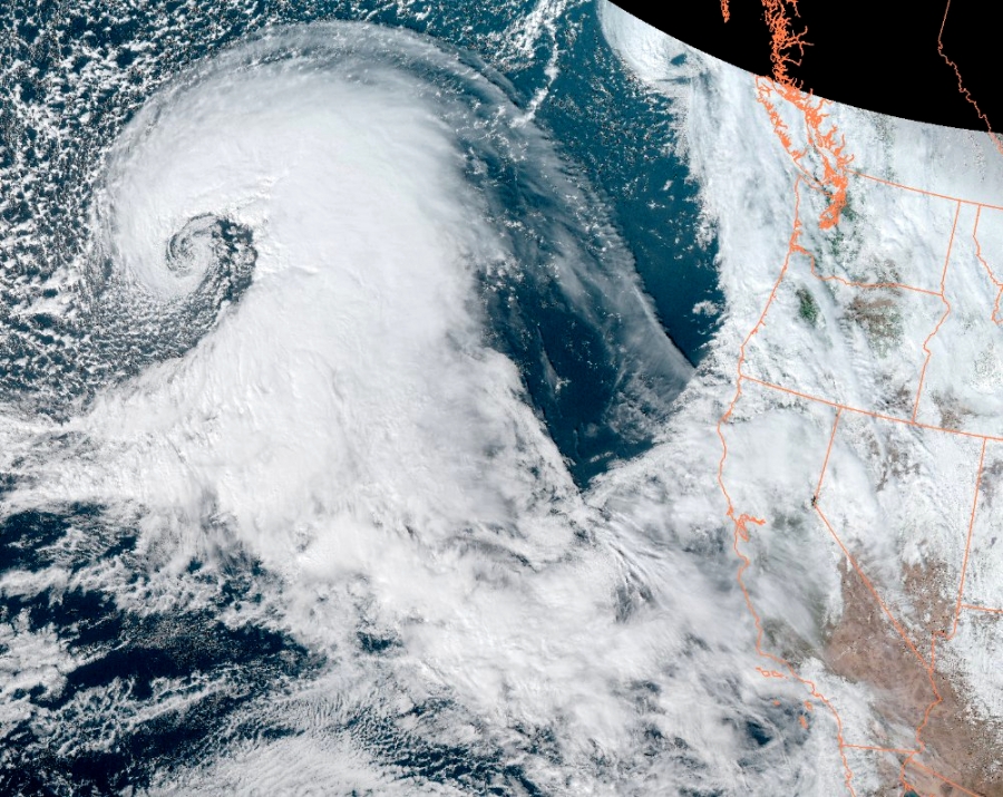
Satellite imagery shows the beginnings of a “bomb cyclone” formation over the Pacific Ocean and an atmospheric river swirling toward the San Francisco Bay Area.
SAN FRANCISCO (KRON) — The National Weather Service is warning Californians Wednesday of a powerful atmospheric river set to bring flooding, mud slides, wind gusts topping 50 mph and “extremely heavy snow rates” to the mountains.
The atmospheric river is connected to a rapidly intensifying low pressure system that will grow strong enough to be classified as a “bomb cyclone.”
“As we prepare for the incoming weather, lets take a moment to pause and look at the visible imagery and marvel at what Mother Nature is sending our way,” the National Weather Service Bay Area wrote Tuesday afternoon.
Satellite imagery shows the beginnings of a “bomb cyclone” formation over the Pacific Ocean and an atmospheric river swirling toward the San Francisco Bay Area.
UCLA climate scientist Daniel Swain said, thankfully, the system will remain far offshore.
A satellite image shows a bomb cyclone over the Pacific Ocean on Jan. 3, 2023. (Image courtesy NOAA)
“A rapidly deepening surface low — i.e., meteorological ‘bomb cyclone’ — will remain well offshore, but the associated warm and cold fronts will bring widespread heavy rain and strong winds to NorCal later Wednesday,” Swain wrote.
(Image courtesy NWS Bay Area)
“This low will generate a strong cold front (associated with another very moist atmospheric river). In fact, this storm will also have an unusually well-defined warm front (at least by California standards),” Swain wrote.
The brunt of the storm will pummel the San Francisco Bay Area on Wednesday. “The storm will rage across the entire Bay Area. Rain will become very, very heavy in mid-afternoon,” KRON4 Meteorologist Lawrence Karnow said.
“We haven’t seen anything like this in quite some time,” Karnow said.
The National Weather Service issued Flood Watches and High Wind Warnings that will be in effect between 4 a.m. Wednesday through 10 a.m. Thursday.
The newest storm in California’s “parade of storms” should not be underestimated, a NWS forecaster wrote. Wednesday will be brutal.
“This will likely be one of the most impactful systems on a widespread scale that this meteorologist has seen in a long while,” wrote one NWS forecaster. “The impacts will include widespread flooding, roads washing out, hillside collapsing, trees down, widespread power outages, immediate disruption to commerce and the worst of all, likely loss of human life.”
Wind gusts are forecast to blow between 20 and 70 mph. People should avoid being outside in forested areas and around trees when the storm hits, officials with the National Weather Service Bay Area said.
The NWS wrote, “Damaging winds will blow down trees and power lines. Saturated soils will allow for trees to topple more easily during this prolonged wind event. The strongest winds will be during the cold frontal passage late Wednesday afternoon through early Thursday morning.”
Natural Disasters, Changing America, News, Resilience Read More
Author Profile
Latest entries
 HeadlinesSeptember 19, 2024This New York City pizza has been crowned No. 1 in world, here's why
 HeadlinesSeptember 19, 2024North Korea launches fresh wave of trash balloons toward South Korea
 HeadlinesSeptember 18, 2024Fun Facts: You would have to click a computer mouse 10 million times to burn a single calorie
 ScienceSeptember 18, 2024Breast milk antibodies protect against rotavirus